How Property Surveys & Boundary Demarcation Work at Ganga Residency garhmukteshwar
Purchasing a freehold plot is one of the most secure real estate investments you can make in the Delhi NCR region. However, the real value of land ownership depends entirely on legal clarity, precise measurement, and physical demarcation. At Ganga Residency in garhmukteshwar, every square yard of land undergoes rigorous digital surveying, total station mapping, and official government revenue verification before it is handed over to buyers.
Whether you choose a 100 sq. yd. or 150 sq. yd. residential plot, our precise boundary demarcation process ensures that your plot dimensions match your registered sale deed down to the millimeter. This comprehensive guide breaks down the step-by-step surveying protocol, revenue department approvals, and physical boundary marking procedures applied across Ganga Residency.
100% Clear Title & Demarcated Freehold Land
Verify plot availability, layout maps, and boundary demarcations directly on our master layout map. Explore verified pricing options or book an engineer-guided site visit today!
View Ganga Residency Master Plan Layout | Check Updated 2026 Price List
Guide Directory & Key Sections
1. Why Demarcation Matters in Real Estate Investments
In unorganized sector developments, land buyers often face conflicts regarding overlapping boundaries, displaced road widths, or inaccurate plot sizes. Boundary demarcation is the legal and technical process of locating, measuring, and physically marking the exact corner points of a specific plot based on approved revenue maps and layout plans.
At Ganga Residency garhmukteshwar, boundary demarcation protects plot owners in several essential ways:
- Guaranteed Plot Dimensions: Eliminates discrepancies between the area mentioned in your registry documents and actual ground reality.
- Zero Overlap Disputes: Laser-guided total station surveys establish clear line-of-sight boundaries between adjacent properties.
- Immediate Construction Readiness: Physical corner pillars allow you to start boundary wall construction or villa development right away.
- Hassle-Free Vastu Alignment: Helps owners easily align their building design with cardinal directions. Review our Vastu-friendly plot layout guide for planning tips.
2. The 5-Step Property Survey Process at Ganga Residency
Our engineering and surveying teams follow a standardized 5-step workflow for every plot delivered to buyers within the township:
Step 1: Revenue Boundary Verification
Engineers cross-reference the master township land record with UP Revenue Department Khasra maps to verify perimeter coordinates.
Step 2: DGPS Grid Alignment
Differential Global Positioning System (DGPS) tools map satellite coordinates to lock in fixed ground control points across wide township avenues.
Step 3: Total Station Corner Marking
Laser-reflecting electronic total stations measure plot lengths, widths, and diagonals to pinpoint four distinct corner coordinates.
Step 4: Pillar Demarcation & Possession
Concrete boundary pillars stamped with plot numbers are permanently embedded into the ground at each corner.
Following boundary physical marking, buyers receive an official Plot Demarcation Certificate alongside their possession documents. Before finalizing your booking, make sure to read our detailed checklist on legal documents to check before purchasing a residential plot.
3. DGPS & Total Station Technology Used on Site
Traditional chain surveys can introduce cumulative measurement errors, especially over large multi-acre residential townships. Ganga Residency uses high-precision digital survey instruments to guarantee mathematical accuracy:
| Survey Technology | How It Works | Accuracy Level | Buyer Benefit |
|---|---|---|---|
| DGPS (Differential GPS) | Connects to satellite networks and reference base stations across Western UP. | Sub-centimeter (<10mm) | Secures external township boundaries against any future land shift. |
| Electronic Total Station (ETS) | Emits infrared laser beams to measure exact horizontal distances and internal angles. | Millimeter precision | Ensures plot corners form exact 90-degree right angles for easier home design. |
| CAD Master Mapping | Converts field measurements directly into digital AutoCAD master plans. | 100% Vector digital accuracy | Allows seamless integration with municipal utility and sewer connections. |
4. Section 143 Non-Agricultural Approvals & Revenue Mapping
A crucial factor in land surveying is ensuring that agricultural land has been legally converted for residential use. Under UP revenue law, Section 143 conversion ensures that land is officially recognized for housing and non-agricultural activity.
At Ganga Residency, every residential block undergoes formal revenue classification before boundary demarcation takes place. For a deeper breakdown on legal land approvals, review this guide on Section 143 land clearances near Garh Ganga.
Additionally, you can review our sister township development at Ganga County or explore independent investment insights via this article on why garhmukteshwar is a top real estate hotspot in 2026.
5. Video Walkthrough: Township Layout & Wide Asphalt Roads
Watch our walkthrough video to see the demarcated plot blocks, wide internal roads, and underground utility infrastructure developed across Ganga Residency:
6. Ganga Residency Demarcated Plots vs Unapproved Private Land
Comparing planned township plots with standalone rural land options highlights why structured boundary demarcation is critical for peaceful property ownership:
| Demarcation Metric | Ganga Residency Gated Township | Unapproved Private Plots |
|---|---|---|
| Measurement Method | DGPS + Electronic Laser Total Station | Manual tape measuring (High error risk) |
| Corner Marking | Permanent RCC Concrete Pillars | Temporary wooden stakes or loose bricks |
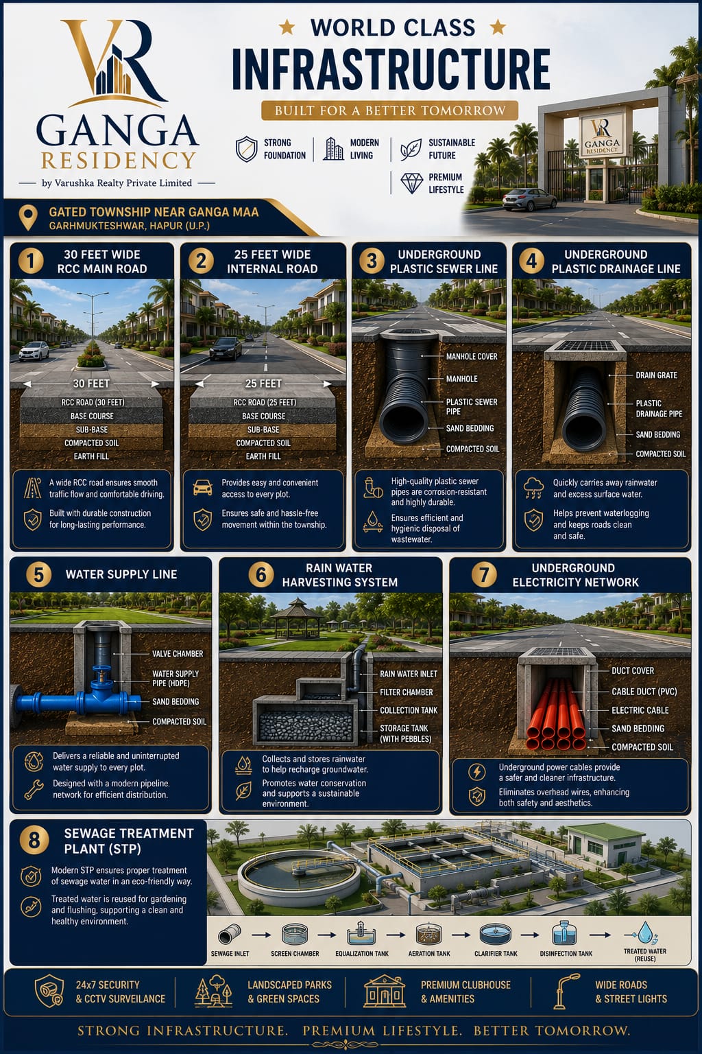
| Road Demarcation | Dedicated 30ft & 40ft asphalt roads locked in master plan | Irregular access lanes subject to encroachments |
| Legal Status | Section 143 Non-Agricultural & Freehold Registry | Agricultural risk without clear conversion |
If you are evaluating budget options, browse our guide on affordable plots in garhmukteshwar under 20 lakhs or review the Ganga Residency location and distance breakdown.
Explore Location & Connectivity
Check Township Amenities
View On-Site Development Photos
Schedule an Engineer-Led Site Tour
7. Frequently Asked Questions
Can I re-measure my plot on-site during possession?
Yes! Our survey team will accompany you during physical possession with an electronic total station device to measure every boundary line in your presence.
What happens if a boundary pillar is damaged during construction?
Ganga Residency keeps digital DGPS coordinate backups for every plot. If a corner pillar is displaced during foundation excavation, our site engineer can re-mark the exact spot using master reference points.
Are internal roads demarcated separately from residential plots?
Yes. All 30-foot and 40-foot internal avenues are demarcated as separate township property, ensuring your full plot area remains untouched by future road maintenance.